
Categories
Flood Plain vs Flood Way, Real Estate in North Bend WA, Real Estate in Snoqualmie, Real Estate in Snoqualmie ValleyPublished June 8, 2026
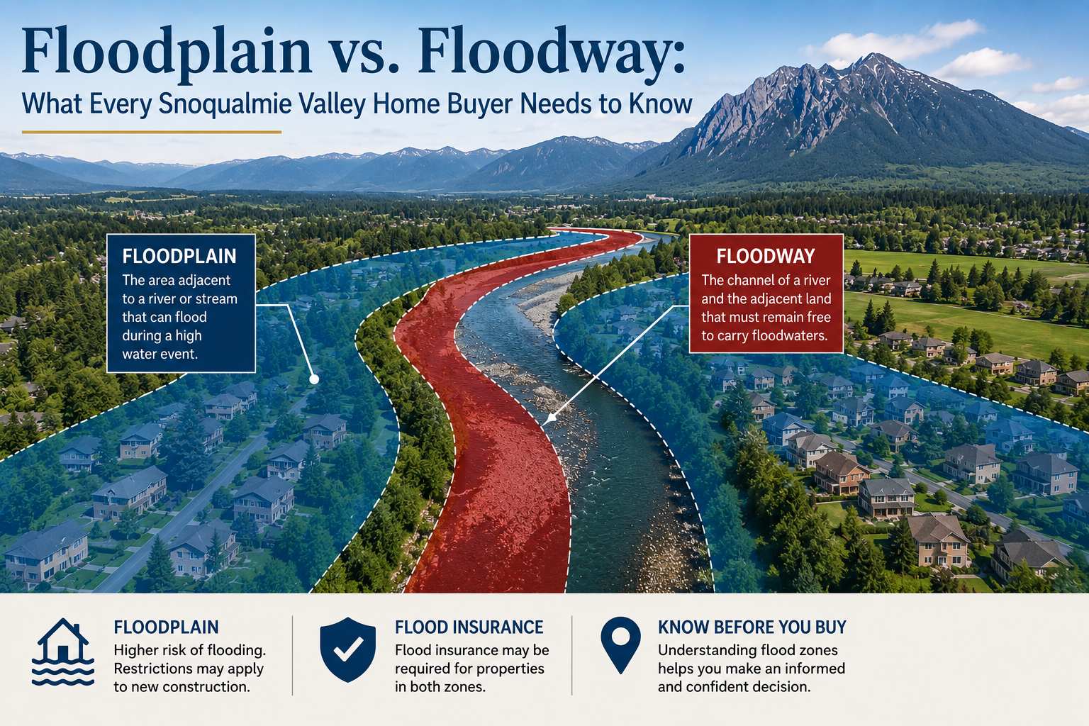
Floodplain vs. Floodway: What Every Snoqualmie Valley Home Buyer Needs to Know

Floodplain vs. Floodway: What Every Homebuyer in North Bend and Snoqualmie Needs to Know Before They Buy
By Sandy Navidi | Local Real Estate Expert, Snoqualmie Valley
If you're buying or selling a home in North Bend or Snoqualmie, there's a conversation we need to have before you ever make an offer — and it has nothing to do with interest rates or square footage. It's about water.
I've worked in the Snoqualmie Valley real estate market for years, and one of the most misunderstood — and most consequential — topics I encounter is the difference between a floodplain and a floodway. These two terms sound similar, but they carry very different implications for what you can build, what you can do with your property, and — critically — what you'll pay for insurance. In some cases, being in the wrong zone can make a home nearly uninsurable at any reasonable cost.
Let me break it down the way I explain it to my clients.
The Floodplain: The Big Picture
Think of the floodplain as the entire area surrounding a river or stream that could potentially flood during a major storm event. Specifically, FEMA defines this as the 100-year floodplain — land with a 1% chance of flooding in any given year. That sounds low, but over the life of a 30-year mortgage, a home in the 100-year floodplain has roughly a 26% chance of experiencing a flood event. And just one inch of floodwater can cause up to $25,000 in damage.
Here's the local reality check: approximately 42% of North Bend's entire land area sits within the 100-year floodplain, including virtually the entire downtown corridor. The South Fork Snoqualmie River runs directly through downtown, and the Middle Fork adds additional exposure on the city's north side. There have been 15 damaging floods from the Snoqualmie River in the North Bend area since 1975 alone. This is not a theoretical risk — it is a lived reality for Valley residents.
Snoqualmie faces similar exposure. Most of downtown Snoqualmie sits within the floodplain of the Snoqualmie River, shaped by the flat valley floor where floodwaters naturally collect as they drain out of the steep surrounding terrain.
The Floodway: The Danger Zone Inside the Floodplain
Now here's where it gets important. Inside every floodplain, there is a smaller, more restricted area called the floodway. Think of the floodway as the express lane — the fast-moving, high-velocity core of the river channel and its immediately adjacent land that must remain completely open and unobstructed for floodwaters to pass.
The floodway is the most regulated, most dangerous, and most destructive portion of a floodplain. FEMA designates it as the area that must carry the full force of a base flood event without raising water levels more than one foot. Development in a floodway is extremely limited. You generally cannot add fill, build new structures, or make substantial improvements to a property in a floodway without an engineering study demonstrating that your project won't raise flood levels upstream or downstream.
To summarize the relationship:
- Every floodway is inside a floodplain.
- Not every floodplain is a floodway.
- The floodplain is the broader flooded area. The floodway is the most restricted, most hazardous channel within it.
- Between the floodway and the outer edge of the floodplain lies the floodway fringe — this area can be developed under certain conditions, typically requiring elevation and flood-proofing.
On FEMA's Flood Insurance Rate Maps (FIRMs), floodways typically appear as hatched or cross-hatched zones, while the broader floodplain shows as a shaded area.
What This Means for Your Home Insurance
This is where the rubber meets the road — or more accurately, where the water meets the wallet.
Standard homeowner's insurance does not cover flood damage. Full stop. You need a separate flood insurance policy, and depending on which zone your home sits in, the cost difference can be dramatic.
If Your Home Is in the Floodplain (but not the Floodway)
If your home is in a Special Flood Hazard Area (SFHA) — FEMA's designation for the 100-year floodplain — and you have a federally backed mortgage, flood insurance is mandatory. You'll purchase it through FEMA's National Flood Insurance Program (NFIP) or a private insurer.
Here's the good news specifically for North Bend and Snoqualmie residents: both cities participate in FEMA's Community Rating System (CRS) and have both earned a Class 5 rating — one of the stronger scores available. That rating directly translates to a 25% discount on NFIP flood insurance premiums for qualifying policyholders.
In practical terms, North Bend's Class 5 CRS rating saves approximately 600 local homeowners an average of $311 per year each, totaling around $150,000 in collective annual savings across the community. These discounts apply to most NFIP policies issued on or after October 1, 2025.
Additionally, providing an Elevation Certificate — a document prepared by a licensed surveyor that establishes your home's elevation relative to the Base Flood Elevation — can further reduce your premium. The higher your home sits above flood level, the lower your insurance cost.
If Your Home Is in the Floodway
If your property is designated within the actual floodway, the insurance situation becomes significantly more complicated and expensive. Floodway properties may face:
- Higher NFIP premiums due to the elevated risk classification
- Difficulty obtaining private flood insurance — many private insurers won't write policies on floodway properties at all
- Financing challenges — lenders may be reluctant to approve mortgages on floodway properties, or may require additional conditions
- Severe restrictions on improvements — you may not be able to renovate, expand, or even rebuild after a loss without a full engineering review
Both the cities of Snoqualmie and North Bend are actively pursuing federal grant programs to help residents in floodway and high-risk floodplain areas either elevate their homes (raising the structure above flood levels) or, in some cases, sell flood-prone properties through acquisition programs.
How to Find Out Which Zone Your Property Is In
Don't guess. Here's how to get a definitive answer:
- King County iMap — the county's online GIS mapping tool shows flood zones overlaid on parcel data
- FEMA's Flood Map Service Center at msc.fema.gov — enter any address to see the official Flood Insurance Rate Map
- FloodSmart.gov — FEMA's consumer-facing resource for flood zone lookups and insurance information
- North Bend Public Works Department — they can provide direct assistance with FIRM zone determinations and flood insurance information for North Bend addresses
- Your real estate agent — this should be me — a knowledgeable local agent will pull the flood map during due diligence and walk you through what the designation means for that specific property
The Bottom Line from Someone Who Knows This Valley
The Snoqualmie Valley is one of the most beautiful places to live in the Pacific Northwest. The river that occasionally floods this valley is the same river that makes it breathtaking. But beauty comes with responsibility, and in this market, that means knowing exactly what zone you're buying into before you sign anything.
Buying in the floodplain doesn't have to be a dealbreaker — thousands of families do it successfully every year right here in North Bend and Snoqualmie. But you need to go in with eyes wide open: understand your zone, get an elevation certificate, know your insurance cost before you close, and work with a local expert who has navigated these waters — literally and figuratively — before.
That's what I'm here for.
Have questions about a specific property's flood designation in North Bend or Snoqualmie? Reach out directly — I'm happy to pull the flood map and walk you through what it means for your purchase.
|


or another way